“Azeri” Fabricated 20 Percent Myth
“Azeri” Fabricated 20% Myth
Figure 10
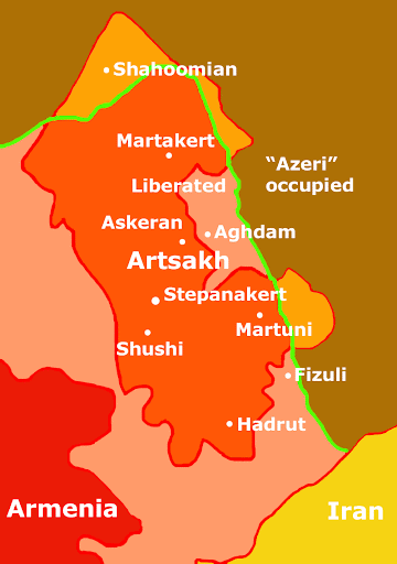
Artsakh liberated territories, real situation
Figure 11
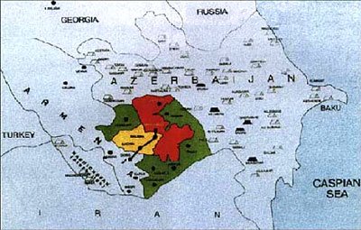
“Azeri” distorted map
The constant sniveling about the 20% “historic Azeri” territories occupied by Armenia is an utterly blatant lie because it includes the area of NKAO, the autonomous Mountainous Karabakh region that was never part of an independent “Azerbaijan”. Neither Artsakh nor Nakhijevan were part of fake “Azerbaijan” when it was being counterfeited on Armenian territory in 1918 and were only treacherously snatched from Armenia following illegal dealings between Lenin and Kemal in 1921 when the already Sovietized fake “Azerbaijan” did not exist as an independent state. On December 10, 1991, 99.89% of the people of Artsakh voted for independence in a legal (even in Soviet terms) referendum. As a result, two independent states emerged on Soviet “Azerbaijani” territory after the fall of the USSR.
Counting the 4,400 square km former NKAO area as “occupied Azeri” territory means that people of Artsakh have occupied their own land. The remaining liberated territories, part of historic Armenian province of Artsakh, amount to 7,086 square km which roughly corresponds to 8% of the area of fake “Azerbaijan”. Even if we were to count the former NKAO area the total would not exceed 13% of fake “Azerbaijan”.
The lie also keeps silent about the fact that of the seven liberated districts, two were partially freed: Armenians control only 35% of Aghdam and 25% of Fizuly, but the impostors cite the entirety of the seven regions being taken by Armenians. On the other hand they, along with their western allies and their media shut up concerning the fact that “Azeri” aggressors have usurped and ethnically “cleansed” Shahoomian and parts of Martakert and Martuni regions of Artsakh totaling 750 square km, i.e. 17% of Mountainous Karabakh proper (for 8% supposed “Azeri” territory), and the Artzvashen district of the Republic of Armenia. This point is not represented in the shamefully debasing “peace” paper put together by the so-called OSCE Minsk Group.
Once more: the seven districts surrounding Artsakh had to be liberated to establish a security buffer, a consequence of “Azeri” actions using the region as a launch pad for air raids, firing Grad rockets, long-range artillery shelling using even ship guns, all of it against people they shamelessly call citizens of “Azerbaijan” who in case of “returning” the territories (just like that!) will “enjoy” the highest level of autonomy. The question arises, how a generation of Armenians who grew up or were born since 1991, could voluntarily choose to exchange their deservedly earned, de facto independence for genocidal Turkic yoke?
Table 3
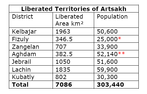
* Only 25% of Fizuly is under Armenian control therefore 25% of the population of 100,000 has been presented in the table.
** Only 35% of Aghdam is under Armenian control therefore 35% of the population of 158,000 has been presented in the table.
The maps presented in this section show the situation as is where on the “Azeri” constructed map, apart from its inaccuracy in terms of the shapes of borders, the picture has been completely distorted to somehow convince the world that Armenia holds 20% of “Azeri” territory, a percentage that is regularly blown further up to a quarter of “Azerbaijan” as well. Not for nothing have the Turks usually been regarded as weak in reasoning, in Turkish logic 8 = 20.
Incidentally, while the 20% figure has been grabbed out of the air, and keeping in mind that the area of historic Armenia is about 400,000 square kilometers, more or less ten times larger that today’s Armenia including Artsakh, it unintentionally (most likely) corresponds with the percentage of Armenian territory that fake “Azerbaijan” occupies. Indeed, it is counterfeit “Azerbaijan” that has been fabricated on 20% Armenian land which it unlawfully occupies and desecrates, not vice versa.
posted by Hellektor at 12:00 PM
![]()

0 Comments:
Post a Comment
<< Home